

San Francisco River- Reserve, New Mexico
A POLITICAL DESIGNATION…
The United States Forest Service in 2002 and an interdisciplinary team with various scopes of professional experience and knowledge evaluated over 99 segments of the river.. They settled a lawsuit with environmental groups which resulted in a settlement identifying 9 river segments as being eligible for some level of protection under the Wild and Scenic Rivers Act. This act introduced by Senators Udall (former) & Heinrich completely discounts the public and scientific Gila National Forest Plan revision process which is ongoing. Both Senators spend a lot of time defending the NEPA process. Yet here, they are ignoring public and agency input.


Rivers Deemed Ineligible
In 2002, 9 river segments were deemed eligible. Senators now claim 424 miles or roughly 69 river segments without NEPA process. No justification! Most the eligible rivers outside the wilderness in the current forest plan were reviewed in 2002 and deemed non-eligible. Those rivers have not changed. Only the political environment has changed which is not a requirement to designate.
Mining Claims
Mineral Creek & White Water were deemed ineligible in 2002 due to dozens of mining claims.
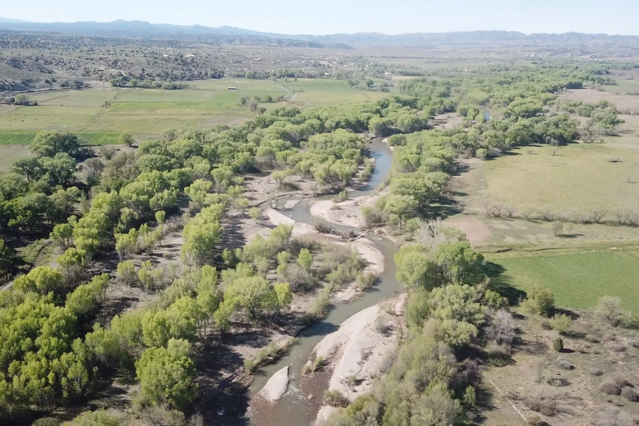
San Francisco River
The San Francisco below Reserve running to Alma is peppered with private property and runs dry every year and did not qualify in 2002 in any of the 3 categories.
Economic Impact Study
NEPA must include an economic impact study which is not on anyone’s radar to complete.
Stop Mining & Timber Harvests
The short stretches of river above Reserve and west of Silver City were not eligible in 2002 and should not be part of the current forest plan. The reasons to have them there now is purely political. As Section 7 of the Act can stop mining and timber harvests above and below those strategically placed locations. (Remember mining is 44% of Silver Cities GDP)
Handicapped/Elderly Restricted Access
The designated Mule Creek location is peppered with camp sites and has a well used 2 track trail for vehicles. Yet that section is being considered as Wild. To justify this the Gila National Forest Service has blocked the 2 track trail stopping handicapped and elderly from using the campsites.
Power Grab
All the rivers being reviewed as eligible outside the wilderness are simply chess pieces being played by our politicians who agree with the philosophy of Centers for Biological Diversity and NM Wild.
ABOUT...
Our Senators along with NM Wild created this Wild & Scenic designation as a means of controlling Southwest New Mexico’s water. They have been deceptive in their promotion. Learn the truth here and join us as a member of Heritage Waters Coalition. It’s time to challenge this betrayal.
Selling Our Water
Our Southwest communities are struggling for water. Our future water demands will only increase. Yet, we are giving away water that New Mexico was awarded in the 2004 AWSA (Arizona Water Settlements Act). Why would our Senators Udall (former) and Heinrich give away our much needed water? Arizona Tribal Reservations have contributed heavily to their campaigns; Gila River Indian Community donated $22,000.00. San Carlos Indian Reservation stored 220,000 acre feet of New Mexico water in 2019. Water that flows into Arizona will likely not be used to irrigate tribal lands. In the past, it has been sold to the Phoenix valley for golf courses, swimming pools and a growing water wasting population. Our Senators have effectively sold out Southwest New Mexico’s water and the communities that depend on it.

“Everything is now for sale. Even those areas of life that we once considered sacred like health and education, food and water and air and seeds and genes and a heritage. It is all now for sale.”
— Maude Barlow

Meetings
New Mexico Senators Udall (former) and Heinrich conducted meetings to which only select Stakeholders in the Wild and Scenic River Act Amendment were invited. The problem is, all residents of five counties in Southwest New Mexico- Grant, Luna, Catron, Sierra & Hildalgo are Stakeholders. The local meetings that Udall (former) and Heinrich’s field representatives conducted resulted in no revisions to the proposed legislation, even though the LOCAL STAKEHOLDERS that were in attendance had substantial objections. The meetings were fluff.
River Corridors
Designated River corridors are at least one-half mile in width. The 1968 Wild & Scenic River Act states that corridors are measured one-quarter mile out on each side of the river from the high-water mark. Who decides where the high-water mark is? The RMP (River Management Plan) custodian, with the assistance from resulting lawsuits filed by radical preservationist groups. One-half mile wide or more will include the best grazing and farming land. Ranchers, farmers, and miners will not be able to clean out their diversions or irrigation structures, because sediment downstream will not be allowed. Rivers change course frequently and those with water rights must move their diversions and equipment to accommodate the change. Changes will not be allowed, so irrigation will likely come to an end.

Farmers & Ranchers
This Wild & Scenic River Act Amendment will begin kicking ranchers and farmers off river 'corridors' outside the Wilderness despite the Senators promises to the contrary. Though their land may not be confiscated, property owners use of their water and property rights will be severely restricted. If they cannot graze or farm their land, they will lose the lower agricultural tax rate and their taxes will go up. Lawsuits from radical preservationist groups could also affect ranchers and farmers- if these groups disagree with the RMP custodian plans for designated river segments, these groups will file lawsuits against the RMP custodian and the individual farmer/rancher.

Protection
The Gila River and its many tributaries ARE PERMANENTLY PROTECTED in the areas proposed by the M.H. Dutch Salmon amendment to the 1968 Wild and Scenic River Act. The Gila River System is PROTECTED by the Federal Wilderness Designation, United States Forest Service, Bureau of Land Management regulations and many other safeguards. THE ADDITIONAL WILD & SCENIC DESIGNATION IS REDUNDANT AND EXPENSIVE.
The proposed legislation will not improve more habitat by further restrictive protections that it would ultimately mandate. Both the Gila and San Francisco Rivers have critical habitat designations for listed threatened and endangered species. A wild and scenic designation will not increase protections beyond these designations.

Mining
All mining- existing and proposed, are specifically targeted by this Wild and Scenic River Act Amendment and could be shut down. The Wild and Scenic River segments called the Gila Box and Las Animas Creek can both affect mining activities. Las Animas Creek flows east toward a large deposit of copper ore which may one day be developed. River Management Plan and its Plan Managers, in addition to selective application of the Endangered Species Act, will have authority to restrict all commerce the entire length of named rivers and creeks and any tributaries connected to them above or below designated segments. Radical preservationist groups recently tried to shutdown mines in New Mexico and they still pursue this goal.

Cost
The cost of more regulations on public land will be extremely high. Forest Service personnel will be required to prepare plans and enforce regulations, increasing their paperwork load, costing millions of dollars and continuing to keep them out of the woods and in their offices at their computers. Our magnificent Gila National Forest will suffer under the M.H. Dutch Salmon Greater Gila Wild and Scenic Act. No funds for maintenance and more government bureaucracy. It is a tale that there will be more trails and better access through the implementation of this Wild & Scenic River Act. The Forest Service will continue to close trails due to lack of funding.

Myths
It is a myth that the Gila and San Francisco Rivers are free flowing rivers. They have dams, diversions and wells from their headwaters all the way to the Arizona Border. The San Francisco River, as it winds into Arizona, it flows into Luna Lake. At the Gila Cliff Dwellings on the West fork of the Gila River begin several irrigation diversions, as well as a number of government, private and business wells. The dam on Sapillo Creek holds Lake Roberts. Sapillo is a significant tributary of the Gila. This dam and multiple diversions are above the Wilderness. The East, West and Middle forks of the Gila gather together just above the wilderness. These upper tributaries provide water for grazing allotments. Where the river tumbles out of the wilderness it flows into the Cliff-Gila valley. There, several diversion dams and municipal, domestic and commercial wells divert water to residential, industrial, agricultural and mining enterprises. Gila River water is diverted and pumped 300 feet up a mesa to fill Bill Evans Lake, where it is stored for use in mining operations. In Arizona, the Coolidge Dam, stops the flowing Gila River to form San Carlos Lake. The Gila River is NOT free flowing. This myth is perpetuated to secure contributions from grant makers and elderly urban dwellers that will never see either river.

Radical Agendas
This designation will serve to advance preservationist groups agenda of establishing core wilderness areas and connecting corridors where human activity is restricted, buffer areas surrounding the cores for limited human activity and islands of human habitation away from the cores. Proponents of this designation are responsible for the closing down of the logging industry, beneficial forest management, and access to our national forests. They are also behind the introduction of the Mexican wolf, efforts to close mines, lawsuits to protect the Mexican spotted owl & NM meadow jumping mouse, efforts to appeal the NM Non-Navigable Water Rule, demonizing ranching and farming, lawsuits for withdrawal of forest grazing permits, elimination of hunting and trapping on public lands, expansion of wilderness & wildlife corridors and opposition to access the only new water available in Southwestern New Mexico. Their focus is on one resource- recreation. At the expense of other resources- water, range, timber and minerals. Why would anyone believe the proponents intentions for this designation are benevolent given their past history?

Logging
Forest fires are burning hotter and larger than they used to. Total destruction is what these fires are leaving behind. Recovery from these fires will take hundreds of years. Is this loss due to the protection of the Mexican spotted owl and New Mexico meadow jumping mouse? The activist groups in New Mexico continue to file lawsuits against the U.S. Forest Service to revise their plans to log our national forests. We have an obligation to demand that our legislators in New Mexico and Washington develop legislation to stop this nonsense. If we continue to pull grazing allotments off the forest, inhibit logging and thinning, all our forests will look like the photo above.
Allow Southwest New Mexicans To Retain Their Drinking Water…
Our citizens deserve to benefit from the waters that originate in our mountains, to use these waters wisely and with conservation as a high priority.

Arizona Water Settlements Act
The AWSA amendment to the Colorado River Basin Project Act was obtained through decades of effort by New Mexico's Congressional delegations and elected and appointed officials. The primary motivation for the Wild & Scenic River designation is to delay and block the hard won recovery of water rights lost in the Arizona vs. California adjudication. With lawsuits stopping 14,000 acre feet of Arizona Water Settlements Act water, 70 million dollars of water flows into Arizona for their use. Permitting for applications for new water via the 68 Lower Colorado Basin Project Act and the Arizona Water Settlements Act amendment would face additional obstacles. They are:
An applicant for a permit to the NM State Engineer could face formal protest of the application by persons advocating protection for the designation. These protests and potential court appeals through the state procedure and courts all the way to federal courts would be very expensive and time consuming and would likely result in few if any AWSA new water use or storage reservoirs being permitted.
When presented with an application for a new permit the New Mexico State Engineer must consider three questions: 1. Will it impair existing adjudicated rights; 2. Will it contribute to the public welfare; 3. Will it promote the conservation of water? A NM State Engineer could be called into litigation in federal court if he grants a permit application above a designated segment.
Designated segments on lands managed by federal agencies would have to convert management of those lands from multiple-use to enforcement of the designation protected values. Given the remoteness of the potential segments, enforcement would have to be done by floating down the rivers, walking or by horseback. The efficiency of enforcement would be compromised and expensive.
Every federal land management agency and every private property owner above and surrounding a designation under the Act are required to manage their lands to prevent any adverse impact to the segment lands property or the quantity or quality of water flowing through the segment. This has WILD AND SCENIC RIVER DESIGNATION IMPACTS implications for timber harvesting, livestock grazing, road maintenance, recreation uses, mineral extraction and reservoir construction, etc.
Mineral entry withdrawals are almost guaranteed for designated segments.